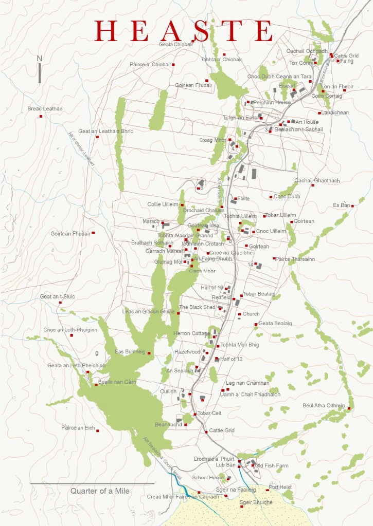
It was over a whisky at New Year 2017 that the idea of creating a map of the Gaelic place names of Heaste, a small crofting settlement in the south of Skye, was hatched. I learnt from Ali MacPherson, the Clerk of the Common Grazing, that the Gaelic names of the landscape features surrounding the township of Heaste had been passed down from generation to generation through an oral tradition, but they had never been written down. Ali was fearful that the names might be lost because crofting was dying out and therefore there was no longer a need for people to name the features of their immediate landscape. Over the period of a year I worked with local residents to map the gaelic place-names and with a Gaelic specialist. The result was two maps, one of the township and one of the settlement.
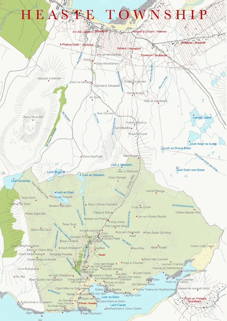
Observations
Scottish Natural Heritage recently published a book on the place-names of the parish of Strath in their Gaelic in the Landscapes series (King and Scammell, 200?). The book contains over one hundred Gaelic place-names in the Strath.
The authors wrote:
The place-names of Strath are intimately connected with the landscape and the lives of the people who have lived there for centuries. Coastal, Hill and man-made features have been named to reflect stories, past-times, and daily routines; by exploring their meanings and history, many details of past lives are revealed.
The above remarks are equally true for Heaste, a small Crofting Township sitting within the parish of Strath.
The oldest place-names in Heaste date from 800 CE when the Vikings settled on Skye. The name ‘Heaste’ is thought to be derived from the Norse for ‘Horse Field’ or ‘Horse Farm’ (Mac an Tailleir, 2003). However, the Ordnance Survey Name Book suggests that the name perhaps derives from Hoestr, meaning ‘uppermost’ [pr perhaps Uppertown’].
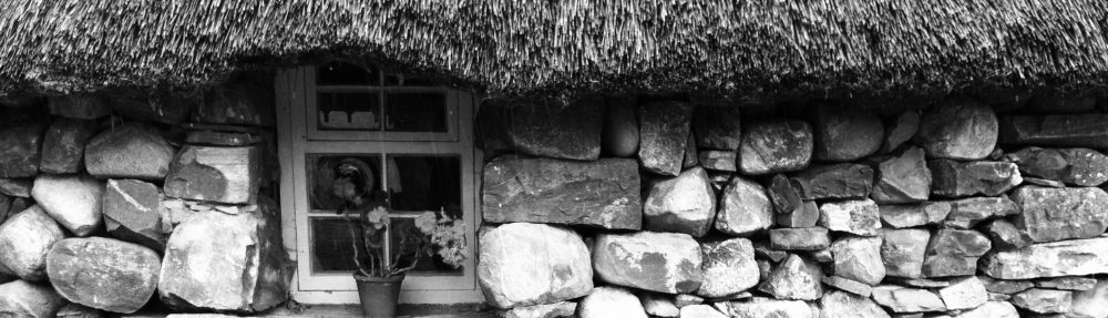
This name is applied to a small district comprising several small farms or crofts all the houses are one storey high thatched and in bad repair, it is situated about four miles to the S.W. [South West] of Broadford (Ordnance Survey 1876-78).
However, the vast majority of place-names in Heaste are of Gaelic origin.
The sheer density of naming in and around Heaste, together with the number of archeological remains suggests that the land has been heavily farmed from at least medieval times. We also know from census records that there were over two hundred people living in Heaste in the early nineteenth century.
Prior to the twentieth century the sea and coast lines were used more intensively than today and this is reflected in the naming of almost every bay, skerry and promontory along the coast.
Inland from the coast the land was farmed, in the eighteenth century by joint tenants of a Club Farm and by the tenants of thirteen Crofts that were laid out by Lord MacDonald’s Estate in the early nineteenth century. For these farmers and crofters place-names helped them to navigate the landscape.
The place-names of Heaste have been named in various ways including:
- Names describing features of the natural landscape
- Names describing man made features
- Names referring to people
- Names relating to myths
Here are some of the more interesting names and their histories:
Dreun nan Caorach: Sheep Drain (MacPherson, 2018) (Anderson, 2019). Dug by locals at the time of the famine in the 1840s. Also known as Starvation Ditch due to the state the folk were in at the time. The project was administered by the landlord, LordMacDonald (MacPherson, 2019).
Geata Ciobhair: Shepherd’s Gate There are eight gates in the boundary (head dyke) between the in-bye (cultivated arable land) land and out-by land (rough grazing). Each gate is named. The other seven are: Geata an Leth Pheighinn: Halfpenny Gate (MacPherson, 2018), Geat an t-Sluic: The Gate of the Hollow (Rafferty, 2019), Geata Bellag: Bellag’s Gate (MacPherson, 2018), Geat an Leathaid Bhric : The Gate of the Speckled Slope (Rafferty, 2019), Cachail Ghaothach: Windy Gate (MacPherson, 2019), Cachail Leth Dhubh: The Half-black Gate (Rafferty, 2019).
Iodhlainn Crotach: Lichen Stackyard (MacPherson, 2018 )(Anderson, 2019). Iodhlainn is a name common in place names. It means stackyard. Crotach is lichen used for dying cloth (MacPherson, 2019).
Lochain Dubha: Black Lochs (MacKinnon, 2018) Ludag (little finger) … haunted Loch Dubh. It was a one-eyed, one handed and one legged, and was often reported near Broadford. This strange creature bears some physical resemblance to the smith in Thinman’s Tale (McDonaugh, 2006: 87).
Loch Dubh nam Breac: The Black Loch of the Trout (MacKinnon, 2018). About 1860 a woman with her coat about her head was often seen by night on the road passing Loch Dubh nam Breac. She was known as ‘ The Rag’ or ‘Slovenly Woman’, ‘Luidead’. She did not answer when spoken to, although an excise man did try in both English and Gaelic. She would vanish as silently and mysteriously as she appeared. Finally a man was found dead at the place and she was never seen again (McDonough, 2006: 87).
Sgeir Gormeil: Gormerlia’s Skerry (MacPhearson, 2019). Gormerlia was kept on this rock by Fuamair Allt Mochaidh – an evil giant who lived on the Morsaig (Sleat) side of Loch Eishort. He was bright yellow (a colour of nobility for the Celts) and stole away Gormeil, a blue eyed Fian girl, putting her on a rocky islet. Her lover tried to rescue her but with a slight nudge of his ankle Mocaidh sent a huge boulder into the sea to swamp the poor lad. The great boulder can still be seen there today and is known as Sgeir Gormeil (McDonough, 2006:17).
Ullieum’s Cnoc, Tobar, Tobhta and Collie: William’s Hill, Well, Ruin and Copse. These place-names are all located on Croft Seven. The Official Census data shows a William McLure living on Croft seven between 1841 and 1911 and it is possible that the places are named after William MacLure. William, son of Donald MacLure, was born in Heaste on 12 June 1834 and the census records his occupation as ‘fisherman’.
Bibliography
| Am Faclair Beag (2018). Accesssed online at: http://www.faclair.com | ||
| Anderson, Sarah, Pat and Angus (2019). Information provided to researcher from Heaste residents. | ||
| Brown, Fiona (2019) Information provided to researcher from Heaste residents. | ||
| Dwelly’s Dictionary (2018). Accessed online at: http://www.dwelly.info | ||
| Forbes, A. R. (1923) Place Names of Skye and adjacent islands. Paisley, Alexander Gardner Ltd. | ||
| King, Jacob and Scammell, Eilidh (2015) Place-names of Strath, Isle of Skye. Perth, Scottish Natural Heritage. | ||
| Mac an Tailleir, Ian (2003) Accessed online at: https://www.parliament.scot/gd/visitandlearn/40900.aspx | ||
| MacKinnon, Neil [No. 1 Heaste] (2018) Information provided to researcher from Heaste resident. | ||
| McDonaugh, Charlotte (2006) Skye Tales. Stories from the Isle o Skye and where they took place. http://www.lulu.com | ||
| MacPherson, Alistair (2018) Information provided to researcher from Heaste resident. | ||
| Ordnance Survey (2005) The Gaelic origins of place names in Britain. Southampton, Ordnance Survey. | ||
| Ordnance Survey (1876-78) Ordnance Survey Name Book: Inverness-shire (Skye) Strath: volumes 10 and 11. Accessed online at: https://scotlandsplaces.gov.uk/digital-volumes/ordnance-survey-name-books/inverness-shire-os-name-books-1876-1878/inverness-shire-skye-volume-11/63 | ||
| Ordnance Survey (1881) Six inches to one statue mile. Sheets XLVI and LI. Southampton, Ordnance Survey. | ||
| Ordnance Survey (1963) NG 6416 and NG 6417 [1:2500 scale map]. Southampton, Ordnance Survey. | ||
| Ordnance Survey (2007) Explorer Series No. 412: Skye-Sleat [1:1250 scale map]. Southampton, Ordnance Survey. | ||
| Ordnance Survey (2018) Ordnance Survey open source digital map. Accessed online at:https://www.ainmean-aite.scot/os-map/ | ||
| Rafferty, Danny (2018) (2019) Advice on Gaelic spellings from Danny Rafferty, South Lochboisdale, North Uist. | ||
| Ward, Janet, (2018) Information provided to researcher from Heaste resident. | ||
| Webster, Helena (2018) Researcher and Heaste resident. |
